ESA’s Mars Express has provided new insights into Mars’s Medusae Fossae Formation, revealing deep layers of water ice, the largest such discovery in the region. This ice could significantly impact our understanding of Mars’s climate history and is crucial for future human exploration. Credit: Planetary Science Institute/Smithsonian Institution
Recent Mars Express data reveals the Medusae Fossae Formation contains extensive water ice layers, offering new clues about Mars’s past and supporting future exploration.
Windswept piles of dust, or layers of ice? ESA’s Mars Express has revisited one of Mars’s most mysterious features to clarify its composition. Its findings suggest layers of water ice stretching several kilometers below ground – the most water ever found in this part of the planet.
Over 15 years ago, Mars Express studied the Medusae Fossae Formation (MFF), revealing massive deposits up to 2.5 km deep. From these early observations, it was unclear what the deposits were made of – but new research now has an answer.
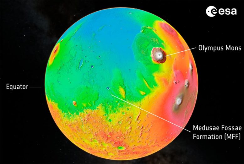
This image shows a height map of the Martian surface, with lowest land in blue and highest in white. Standing at an impressive 22 km, Olympus Mons is the tallest volcano in the entire Solar System.
The Medusae Fossae Formation (MFF) is an interesting region close to the equator. It consists of a series of massive wind-sculpted deposits measuring hundreds of kilometers across and several kilometers high. Found at the boundary between Mars’s highlands and lowlands, the MFF is possibly the biggest single source of dust on Mars, and one of the most extensive deposits on the planet.
Credit: ESA
“We’ve explored the MFF again using newer data from Mars Express’s MARSIS radar, and found the deposits to be even thicker than we thought: up to 3.7 km thick,” says Thomas Watters of the Smithsonian Institution, USA, lead author of both the new research and the initial 2007 study. “Excitingly, the radar signals match what we’d expect to see from layered ice, and are similar to the signals we see from Mars’s polar caps, which we know to be very ice rich.”
If melted, the ice locked up in the MFF would cover the entire planet in a layer of water 1.5 to 2.7 m deep: the most water ever found in this part of Mars, and enough to fill Earth’s Red Sea.
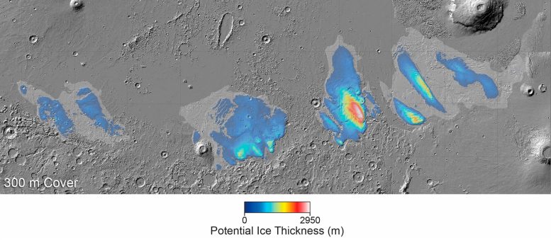
Mars’s Medusae Fossae Formation (MFF) consists of a series of wind-sculpted deposits measuring hundreds of kilometers across and several kilometers high. Found at the boundary between Mars’s highlands and lowlands, the features are possibly the biggest single source of dust on Mars, and one of the most extensive deposits on the planet.
But this dry layer seems to hide a secret. A team of researchers used Mars Express radar data to peer below the surface. What they found was a top layer of dust that covers what seems to be a thick layer of deposits rich in water ice. This map shows the estimated amount of ice within the mounds that form the MFF, indicating that the ice-rich deposits are up to 3000 m thick.
The researchers estimate that the layer of dry material (likely dust or volcanic ash) covering the ice is 300–600 m thick. This map shows the ice thickness if we assume that the dust is 300 m thick. In this case, the total volume of water ice contained within the MFF deposits would be 400,000 km3, or if it melted, enough to cover Mars in an ocean of water 2.7 m deep.
If the dust layer is instead 600 m thick, the water ice layer would be thinner, and the total volume of water ice contained within the MFF deposits would be 220,000 km3, or if it melted, enough to cover Mars in an ocean of water 1.5 m deep.
Credit: Planetary Science Institute/Smithsonian Institution
Alternating Layers of Ice
The MFF consists of several wind-sculpted features measuring hundreds of kilometers across and several kilometers high. Found at the boundary between Mars’s highlands and lowlands, the features are possibly the biggest single source of dust on Mars, and one of the most extensive deposits on the planet.
Initial observations from Mars Express showed the MFF to be relatively transparent to radar and low in density, both characteristics we’d see from icy deposits. However, scientists couldn’t rule out a drier possibility: that the features are actually giant accumulations of windblown dust, volcanic ash, or sediment.
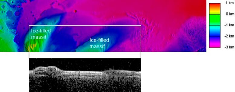
Close to Mars’s equator lies the Medusae Fossae Formation (MFF), a fascinating wind-sculpted region that may be the biggest single source of dust on Mars.
When Mars Express turned its MARSIS radar sounder instrument towards the MFF, it revealed a surprise. The radar signals that echoed back matched what we’d expect to see from layered deposits rich in water ice.
In this image, the white horizontal line on the colored height map of Mars’s surface (top) shows a narrow stretch of land that was scanned by MARSIS. The pop-out below shows the radar data collected by the instrument that reveals the subsurface; the brighter the area, the stronger the radar echo received from that area.
The white line covers two mounds separated by a valley. These mounds are clearly visible in the radar data below. Analysis of the radar data suggests that beneath a thick layer of dry material (likely dust or volcanic ash), the mounds are filled with water ice.
Credit: CReSIS/KU/Smithsonian Institution
“Here’s where the new radar data comes in! Given how deep it is, if the MFF was simply a giant pile of dust, we’d expect it to become compacted under its own weight,” says co-author Andrea Cicchetti of the National Institute for Astrophysics, Italy. “This would create something far denser than what we actually see with MARSIS. And when we modeled how different ice-free materials would behave, nothing reproduced the properties of the MFF – we need ice.”
The new results instead suggest layers of dust and ice, all topped by a protective layer of dry dust or ash several hundred meters thick.
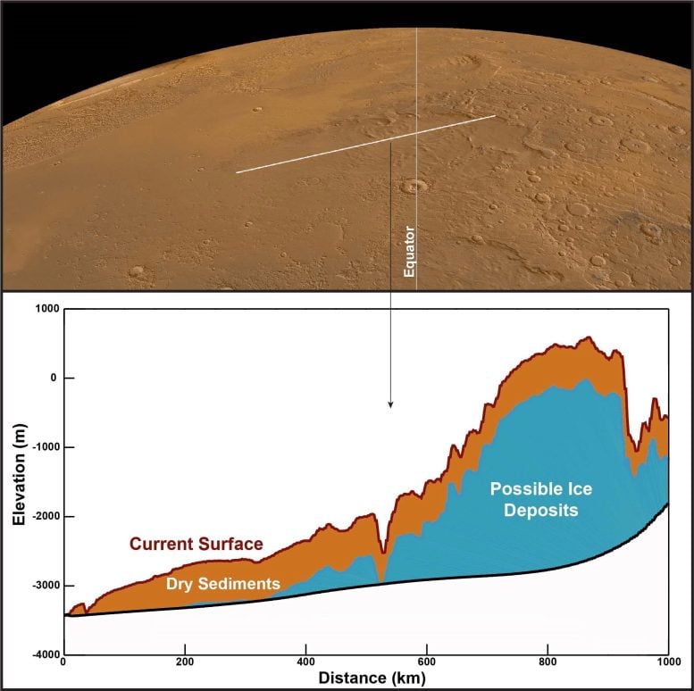
Close to Mars’s equator lies the Medusae Fossae Formation (MFF), a fascinating series of wind-sculpted deposits that may be the biggest single source of dust on Mars.
When Mars Express turned its MARSIS radar sounder instrument towards the MFF, it revealed a surprise. The radar signals that echoed back from below the surface match what we’d expect to see from layered deposits rich in water ice.
In this image, the white line on Mars’s surface (top) shows a stretch of land that was scanned by MARSIS. The graph below shows the shape of the land and the structure of the subsurface, with the layer of dry sediments (likely dust or volcanic ash) in brown and the layer of suspected ice-rich deposits in blue. The graph shows that the ice deposit is thousands of meters high and hundreds of kilometers wide.
If all the suspected water ice in the MFF melted, it would cover Mars in an ocean of water up to 2.7 m deep.
Credit: CReSIS/KU/Smithsonian Institution
Future Exploration and Collaboration
Although Mars now appears to be an arid world, the planet’s surface is full of signs that water was once abundant, including dried-up river channels, ancient ocean and lake beds, and water-carved valleys. We’ve also found significant stores of water ice on Mars, such as the enormous polar caps, buried glaciers nearer the equator, and near-surface ice laced through Martian soil.
Massive stores of ice near the equator – such as those suspected to lurk below the dry surface of the MFF – couldn’t have formed in the planet’s present climate. They must have formed in a previous climate epoch.
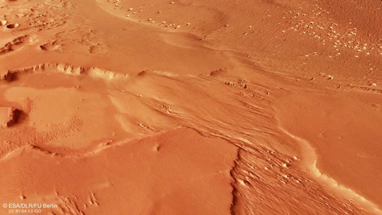
This oblique perspective view of Medusae Fossae on Mars was generated from the digital terrain model and the nadir and color channels of the High Resolution Stereo Camera on ESA’s Mars Express. Credit: ESA/DLR/FU Berlin, CC BY-SA 3.0 IGO
“This latest analysis challenges our understanding of the Medusae Fossae Formation, and raises as many questions as answers,” says Colin Wilson, ESA project scientist for Mars Express and the ESA ExoMars Trace Gas Orbiter (TGO). “How long ago did these ice deposits form, and what was Mars-like at that time? If confirmed to be water ice, these massive deposits would change our understanding of Mars climate history. Any reservoir of ancient water would be a fascinating target for human or robotic exploration.”
The extent and location of these icy MFF deposits would also make them potentially very valuable for our future exploration of Mars. Missions to Mars will need to land near the planet’s equator, far from the ice-rich polar caps or high-latitude glaciers. And they’ll need water as a resource – so finding ice in this region is almost a necessity for human missions to the planet.
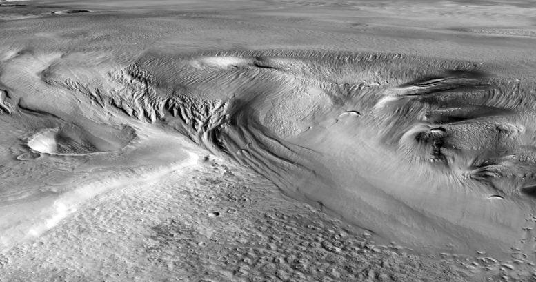
This perspective view shows Eumenides Dorsum, part of Mars’s Medusae Fossae Formation (MFF). The MFF consists of a series of wind-sculpted deposits measuring hundreds of kilometers across and several kilometers high. Found at the boundary between Mars’s highlands and lowlands, the deposits are possibly the biggest single source of dust on Mars, and one of the most extensive deposits on the planet.
But this dust seems to hide a secret. Over 15 years ago, ESA’s Mars Express studied the MFF, revealing that the dust covered massive deposits up to 2.5 km deep. From these early observations, it was unclear what the deposits were made of. A team of researchers has now explored the MFF again using newer Mars Express radar data and found the deposits to be even thicker than previously thought: up to 3.7 km thick. And now it’s clear that these radar signals match what we’d expect to see from layered deposits rich in water ice.
If melted, the ice locked up in the MFF would cover the entire planet in a layer of water 1.5 to 2.7 m deep: the most water ever found in this part of Mars, and enough to fill Earth’s Red Sea.
Credit: Caltech/JPL Global CTX Mosaic of Mars/Smithsonian Institution
“Unfortunately, these MFF deposits are covered by hundreds of meters of dust, making them inaccessible for at least the next few decades. However, every bit of ice we find helps us build a better picture of where Mars’s water has flowed before, and where it can be found today.”
While Mars Express maps water ice to a depth of a few kilometers, a view of near-surface water is provided by Mars orbiter TGO. This orbiter is carrying the FREND instrument, which is mapping hydrogen – an indicator of water ice – in the topmost meter of Martian soil. FREND spotted a hydrogen-rich area the size of the Netherlands within Mars’s Valles Marineris in 2021, and is currently mapping how shallow water deposits are distributed across the Red Planet.
“Together, our Mars explorers are revealing more and more about our planetary neighbor,” adds Colin.


